
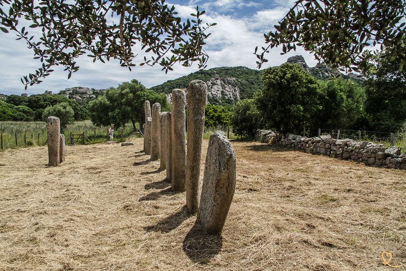
In the town of Sartène, the Cauria Plateau is home to one of Corsica’s most significant prehistoric sites. There, we discovered three iconic sites spread across 60 hectares: the I Stantari stone alignment, the Funtanaccia dolmen, and Renaghju. In this article, check out our photos and all our tips for making the most of your visit to the Cauria archaeological site.
Here are some helpful tips with pictures to help you get the most out of your visit and have a great time!
This guide is completely independent, based on our experiences. We visited the region anonymously, making our own choices and paying our bills in full.
Why Visit the Cauria Archaeological Site
Is the Cauria archaeological site worth a visit? Our opinion:
Yes, the Cauria archaeological site is worth a visit. We enjoyed the opportunity to explore three different megalithic monuments—including carved menhir statues and a dolmen—all in a single outing. The site contains more than a hundred monoliths and fragments, most of which still lie on the ground, providing a fairly accurate picture of the extent of the ancient settlement on the plateau.
It is one of Corsica’s most important prehistoric sites.

It is one of the most beautiful prehistoric sites in the Sartène region. If you’re interested in Corsican prehistory, you can also combine your stay with a visit to the prehistoric site of Filitosa, another major site of megalithic culture on the island. We recommend that you allow enough time to explore the three monuments in Cauria, which are located a few hundred meters apart on the plateau.
Our favorite moments
We particularly liked it:
- The two menhir statues at I Stantari, among the most iconic in Corsica, whose carved faces feature a dual motif—both anthropomorphic and phallic.
- The Funtanaccia dolmen, the best-preserved on the island, whose stone capstone still rests on its six original pillars.
- The tranquility of the plateau, surrounded by rock formations


How to Get to the Cauria Archaeological Site: Directions and Map
Where is the Cauria archaeological site located?
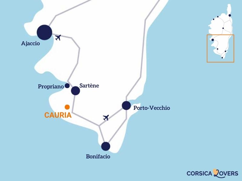
- On the Cauria Plateau, in the town of Sartène, in Southern Corsica
- Travel time from Sartène: about 15 minutes (10 km south on the RT40, then toward Tizzano on the D48)
- Here is a map to help you find your way:
How to get there? Access road
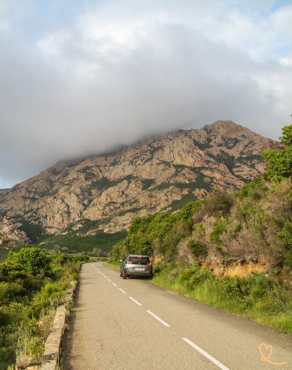
We drove to the site, south of Sartène via the RT40, for 10 km toward Tizzano, and then followed the D48. Next, continue by following the signs for “Stantari” and “Funtanaccia” or “Cauria” (depending on the signs) along the D48a, which passes through the hamlet of Rinaghju.
The road then narrows to a small paved lane, lined with dense scrubland of holm oaks and shrubs, where we came across a few wildflowers along the roadside. A trail then appears on the right; the site is accessible on foot, about a 10-minute walk away.

Parking
At the end of the small road, an unpaved parking area—made of dirt and gravel—accommodates visitors’ vehicles. We found it to be rather basic but functional, surrounded by trees that provide a little shade. It fills up quickly during peak season.

OUR TIPS FOR RENTING A CAR IN Corsica
- Compare prices on our preferred platform: DiscoverCars – one of the best rated sites.
- Choose a car that is powerful enough (the roads are steep) but compact (some passages are narrow).
- Remember to take outcomprehensive insurance (some roads are winding and narrow).
- There is a lot of demand, book it early.
Useful tips: duration, schedules, difficulties…
Schedules and prices, duration, difficulty
Access to the Cauria Plateau is open to the public and free of charge.
Allow between 1 hour and 1 hour and 30 minutes for a self-guided tour of the Cauria Plateau, taking the time to explore all three sites.
Access from the trail to the I Stantari stone circle is on foot; it takes about 10 minutes to walk there, and the path is not particularly difficult. However, we recommend wearing sturdy shoes, as the terrain remains natural throughout the entire course. Especially if it rained earlier.

Advice on how to visit
A site map, posted on-site, indicates the recommended route for the tour as well as the location of the oak grove and the wetland area to be crossed between the monuments. The trail connects the I Stantari stone alignment to the Funtanaccia dolmen, and then to the Renaghju stone alignment.

Visiting with children
Signs posted on the site remind visitors to keep an eye on their children and not to approach the livestock that sometimes grazes freely around the monuments.
Catering, Toilets and Facilities
Nothing on site
WHERE TO STAY IN South Corsica
Our favorites: neighborhoods and hotels
Option 1: Bonifacio and its historic atmosphere
Hotel Cala di Greco overlooking the citadel! – Check photos and availability
See our selection of hotels.
Option 2: Around Porto-Vecchio, with your feet in the water
Hotel Mariosa with beach, pool, restaurant…
– Check photos and availability
See our selection of hotels.


The I Stantari Alignment: Between Menhir Statues and Armed Stelae
The earliest occupation of the site is believed to date back to around 5,700 years before our era, in the midst of the Early Neolithic period: a group of people is thought to have settled against the rocky slope of Punta di u Grecu, taking advantage of a spring and a nearby body of standing water. The site was then abandoned for a time before being reoccupied: the number of standing stones decreased from about 60 around 4500 BCE to approximately 180 in the first millennium BCE.

There are four major stages that help us understand the evolution of the monument we see today. It all began in the Middle Neolithic period, between approximately 4500 and 4100 BCE, with the erection of modest stelae no taller than 80 cm. The site then evolved into its first true monument, arranged in two rows oriented northeast-southwest, which is believed to have been built before 1500 BCE, during the Middle Bronze Age. Then comes a third phase, which we consider the most spectacular: a second monument takes shape— this time, likely consisting of three rows oriented north-south—featuring the large menhir statues and carved stelae that we admire today.
A final phase marked the monument’s decline: between 200 and 50 BCE, during the Romanization period, it fell partially into ruin. Much later, generations of farmers would collect some of these stones to build fences or sheep pens in the surrounding area.

Menhir statues and carved stelae
These monoliths are part of a monument built at the end of the Bronze Age and may represent famous figures, warriors, or clan leaders. On the east-facing side, the sculpture resembles a warrior: it features a helmet marked by two small indentations, a sword, a breastplate, and a triangular piece that experts interpret as a loincloth-like protective garment held in place by a belt.

The Renaghju Alignment, a lesser-known but equally ancient site
Although less visited than its neighbor, the Renaghju stone alignment once consisted of some thirty standing stones, arranged in two clearly distinguishable groups: the first oriented northeast-southwest, the second north-south. We enjoyed the tranquility of this second site, which complements the first in helping us understand the history of the plateau.

Determining the exact age of a stone remains a challenge that cannot be met directly by examining the stone itself: archaeologists must cross-reference several indirect sources, whether they be traces of earlier occupations, the fill material in pits, or the materials used to secure the monoliths in place.

OUTDOOR ACTIVITIES
EN South Corsica
- Sea kayaking under the cliffs of Bonifacio – see options
- Diving – see options
- 4WD tour – see options
- Introduction to canyoning at Pulischellu – see availability
- Complete canyoning experience at Pulischellu – see availability

A very pleasant walk
We especially enjoyed the walk between the sites, with its beautiful trees, rock formations, and peaceful atmosphere…

The Funtanaccia Dolmen, an extraordinary burial monument
The dolmen stands atop a natural hill and, among all Corsican burial monuments, remains the one most commonly associated with the island. We were impressed by how well-preserved it was.
We took the time to examine its structure: a single, heavy stone slab, carved from fine-grained granite, covers a chamber bounded by six roughly hewn standing stones, which archaeologists call orthostats.

Three stand on the west side, two on the east side, and one more on the north side. The site is believed to date back to the 2nd millennium BCE, a period well after the very first megalithic tombs in the region, which appeared around 3000 BCE. The room, which faces north-south, was once sealed off by a flat stone; only the threshold has survived to this day. You’ll also notice that the canopy, which is 3.40 meters long and 2.90 meters wide, rests solely on this handful of pillars, giving the monument an almost suspended appearance.
The origin of the name Funtanaccia is intriguing: it is said to mean “bad fountain,” a reference to a nearby water source that was considered unreliable. Another name is used locally: “stazzona di u Diavulu” (the Devil’s Forge), which suggests an ancient clash between Christian practices and the ancient pagan cults associated with this place.

Complemented by the Sartène Museum
To make the most of your visit, we recommend taking a detour to the Museum of Corsican Archaeology, located in Sartène on Boulevard Nicolaï. In particular, it features ceramics from excavations conducted on the Cauria Plateau.

PLAN YOUR TRIP TO Corsica
Inspiration destinations

Best of
- The most beautiful beaches of Corsica
- The most beautiful villages of Corsica
- The most beautiful cities of Corsica
- The most beautiful destinations in Corsica
- The museums of Corsica
- Hidden gems in Corsica
- The most beautiful natural pools
- What to do in North Corsica
- Best things to do in South Corsica
- Canyoning in Corsica
Where to stay