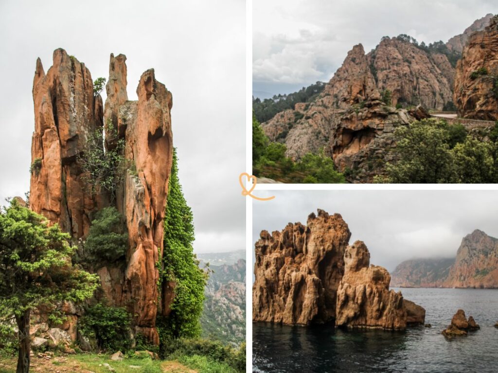
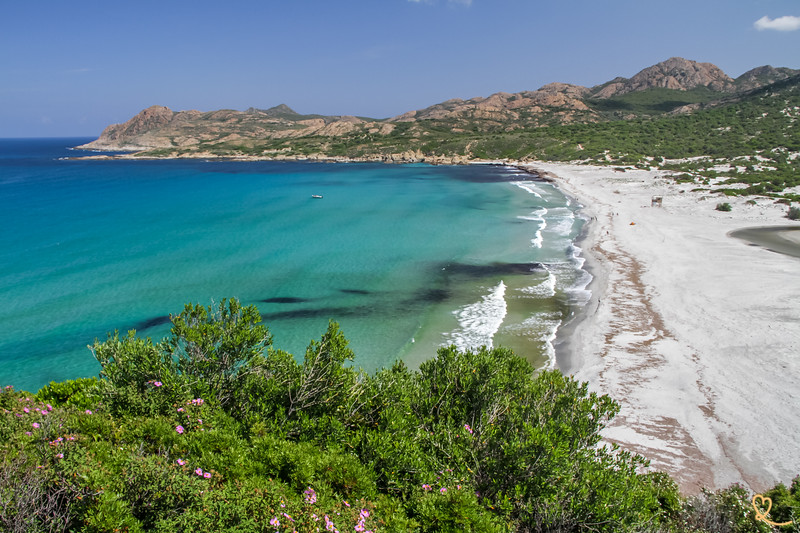
Classified by Unesco, the calanques de Piana are one of the most important places in Corsica. The steep red cliffs offer beautiful scenery!
But, how to visit them? What are the best options?
By boat, on foot, by car, when, how long… Here are all our tips to help you, based on our unforgettable experiences with our photos.
Are the calanques de Piana worth it?
For anyone visiting Corsica, the calanques de Piana are a must-see (or a must-stop if you are on a road trip).
The road is winding and long, whether you come from Calvi in the North or Ajaccio in the South.
The question is: are the calanques de Piana worth it?

Our review
Yes. Absolutely. The calanques de Piana are worth the detour.
It is one of the most beautiful places in Corsica and the whole Gulf of Porto is one of the most beautiful destinations to go to.
The rocks have intense shades of pink, orange and red. This phenomenon intensifies at sunset when the light is weak.
Moreover, as it is a hard rock, it is straight with fractures. Erosion has created large shapes that may remind us of mystical animals.
It is quite mesmerizing to watch!

What are the calanques de Piana?
The calanques (also called calanches of Piana) are creeks and high cliffs of an intense orange/red color. They are located in the Gulf of Porto.
It is a geological formation made of red porphyry which is a magmatic rock (the origin of Corsica is volcanic).
This hard rock has been sculpted by the wind and the sea creating a natural work of art.
Virtual visit – video
First of all, in case you are not yet convinced to visit this amazingUnesco site, here is our short video on exploring the Corsican creeks.
And if you are already convinced, it will help you dream of being there even more!
How to visit the calanques de Piana: map and options
Before sharing with you lots of pictures of the different parts of the creeks, here are all our advices to choose how to visit them.
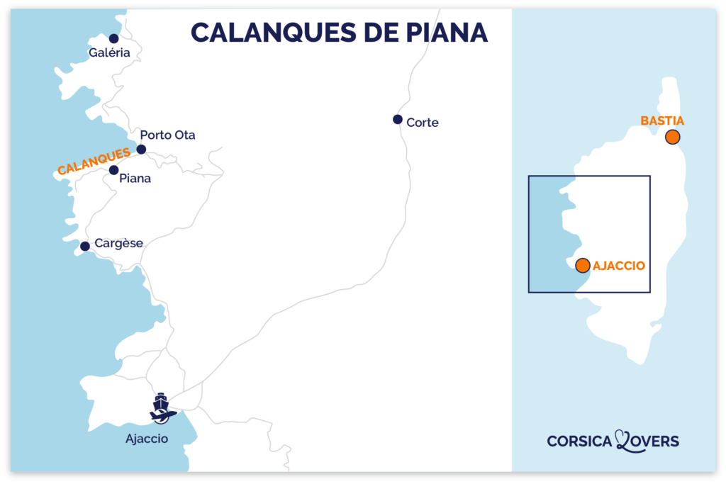
Where are the calanques de Piana?
- On the central-western coast of Corsica
- Southern part of the Gulf of Porto
- The whole area is only accessible by a narrow road, so driving times are quite long.
- The road D81 crosses them
- Ajaccio to Piana – 1h45 by car
- Calvi to Piana – 2h15 by car
- Bastia to Piana – 3h30 drive
- Here is a map to help you find your way
- And see all our tips for planning a dream trip to Corsica here
OUR TIPS FOR RENTING A CAR IN Corsica
- Compare prices on our preferred platform: DiscoverCars – one of the best rated sites.
- Choose a car that is powerful enough (the roads are steep) but compact (some passages are narrow).
- Remember to take outcomprehensive insurance (some roads are winding and narrow).
- There is a lot of demand, book it early.
How to get there?
You have 2 options to get to the calanques de Piana:
- By Road
- On a boat trip
Car
If you really want to explore Piana and the whole region, you have to go there by car.
There are only 3 ways to get there by road:
- From the North and Calvi by the D81
- From the South and Ajaccio by the D81
- From the mountains and Corte, by the D84
In all cases there are narrow and winding roads. But they are well secured, so no fear of going off into the void.

Boat
It is also possible to see part of the Gulf from several cities on the west coast. There is:
- tours of the calanques from Ajaccio,
- from Cargese
- and from Calvi
See a lot of options for boat tours on Viator and on Getyourguide.
How to visit them?
3 options to appreciate the rock formations of Piana:
- By boat
Sailing along the walls to Capo Rosso on a boat allows you to realize their size and the cuts in the rock. The more cracks you can get into. - On foot
Hiking in the creeks allows you to get closer to the rocks, to observe them more closely and to enjoy the views of the Gulf. - By car
To drive the road dug in the creeks is already a very beautiful experience, the views are very beautiful on the rocks and on the gulf. And you can continue climbing towards the inland villages such as Ota and Evisa for even more unforgettable views.

We liked all 3 options and will show you each with photos later in the article.
But the boat trip to the calanques de Piana is, in our opinion, the best.
It gives you a complete overview of the geological system and allows you to really realize how the landscape is shaped and how large the area is.
And if you really like rock formations, we recommend you to combine it with an excursion around the Scandola Reserve(see our article).
See a lot of options for boat tours on Viator and on Getyourguide.
Subscribe to our Newsletter
- Get away from it all with Region Lovers’ beautiful destinations!
- Once a month
- Advertising-free
Practical advice
How much time to allow
- I recommend 2 to 4 days to explore the area. It is really worth it.
- The easiest is to stay in Piana or Porto, but Cargèse is also a good option if you want to enjoy beautiful beaches. The journey will be a little longer each day.
When to visit the calanques de Piana?
If you can avoid the summer months, your experience will be much better.
The roads are narrow, so when there are all the tourists on summer vacation, the experience becomes less enjoyable.
No preferred day.
And as for the time of day, prefer the late afternoon when the sun goes down and hits the cliffs and they are even more colorful.

Even if the weather is not great, go ahead. On the contrary. Cloud cover is best for enjoying the cliffs, as it will allow you to see more detail and color.
In any case, book your boat tours in advance to have space!
See a lot of options for boat tours on Viator and on Getyourguide.
Where to park?
For hiking, you will find a few small parking lots along the main road.
And in Porto-Ota, where the boats leave, there is a large free parking lot south of the village. This is the beach parking lot.
Then you pass over a small bridge to reach the village and the boats.

Where to sleep near the calanques de Piana
3 main options to stay in the area:
- Piana
- Porto Ota
- Cargèse (30min from Piana)
Otherwise, you can sleep further away at:
- Calvi – 2h15 drive – see the best rated accommodations
- Ajaccio – 1h45 drive – see the best rated accommodations
STAYING NEAR THE CALANQUES OF Piana
To enjoy this show, it is better to spend a night or several!
The colors change with the sunset and the weather.
Our suggestions:
Option 1: Piana village
Sleep on higher ground in the village of Piana, in the heart of the Calanques.
Many hotels have incredible views of the Gulf.
- Hotel Scandola and its views of the Gulf of Porto – see prices, photos and availability
- Hotel Capo Rosso and its famous swimming pool with view – see prices, photos and availability

Option 2: Porto Ota village
Spend the night in Porto Ota, the village at the center of the gulf. It’s ideal for boat tours.
- Residence Capu Seninu with mountain views – see prices, photos and availability
- Hotel les Flots Bleus with its view of the Genoese tower – see prices, photos and availability
See all our reviews in our article: where to sleep in Piana
Option 1: the calanques de Piana by boat (from Porto Ota)
Let’s start with the fantastic tour that takes you by boat from Porto Ota along the cliffs to Capo Rosso.
About the boats
Different types of boats allow you to visit the calanques and Scandola.
It’s up to you to choose what you prefer:
Medium size boats

- Advantages: there is a covered area and you can move around
- But: the groups are more numerous and the maneuverability more limited
Speedboat

- Advantages: small groups, possibility to get very close, fun speedboat experience
- But: no possibility to stand up, no protection from the rain, no possibility to stabilize for the pictures
See a lot of options for boat tours on Viator and on Getyourguide.
Our tips for a better experience
- Choose a late afternoon visit so that the colors are more intense.
- Bring binoculars to see the details and spot the birds
- Go even if the weather is not good – with rain, the sea can be calmer and the clouds are better to see all the details in the cliffs.
- For this tour, both sides of the boat are good, but we spend more time on the way to Capo Rosso, so we saw more sitting on the left side of the boat.

The calanques de Piana in pictures
The boat takes you first out of the port of Porto Ota. You can see the famous square tower, a rarity in Corsica

And soon after, you get closer to the cliffs. Some sections have a mixture of pink and grey rocks.

You can clearly see the strata in the rocks.
Inside the cracks grow many plants. One of them is the rare Dianthus gyspergerae.

The very straight and steep shapes of these cliffs are due to the fact that the granite rock is very hard. Thus, erosion does not cause it to break so easily and it remains huge and healthy.
The calanques create a mini V-shaped mountain range. The highest point reaches 698m. So you can imagine how impressive these straight cliffs are when you approach their base with the boat!

Rare birds enjoy this environment as much as we do, with large saw nests installed at the top of points. We spotted this little bird on the picture below (that’s why we advise you to bring binoculars…).

Sometimes, some sea pillars appear near the cliffs. They are made of the same colored rock.

Erosion by the sea has created cavities and cracks. This makes the experience even more fun when looking through it.


Visiting the calanques de Piana by boat takes you to the cliffs under the Capo Rosso. This is the last peak in the photo below. It reaches 330m of altitude. It is the highest cliff of Corsica.
At the top is the Turghju Tower, but because of the clouds we can’t see it here. There is a nice hike that takes you there (more info later in the article).

Definitely one of the best things to do in Corsica(see our list).
HOW TO GET TO Corsica

Option 1: by ferry
Departure from France and Italy
- See all ferry options in our article
- Compare schedules, prices and availability directly
Advantage: you can take your car!

Option 2: by plane
Airports in Bastia, to visit the North, Figari to visit the South, or Ajaccio convenient for all Corsica.
Compare flights!
Option 2: Calanques to Piana by car
The classic way to experience the Calanques is to cross the only road dug into the rock.
Anyway, if you come from Ajaccio to Porto Ota, you have no other choice than to take this road (unless you make a detour through the mountains via Vico and Evisa).
About the Corsican creeks road

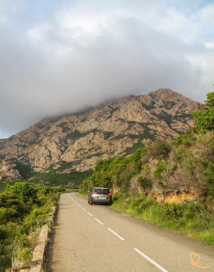
The road to the calanques de Piana is the D81 which cuts through the red cliffs. North of Piana, the winding road of 2 to 3 kilometers is quite impressive.
In some sections, it is not wide enough to pass larger vehicles. That’s why there are regular places cut in the rock to shift and cross. But these are not parking spaces! We have seen people leaving their cars unattended there, which blocks the traffic.
Tips for crossing the creeks by car

- It is better to leave very early to avoid traffic and have time to enjoy the trip.
- The best colors are in the late afternoon/sunset, but the road is still very busy because everyone has the same idea (especially with the summer crowds)
- Towards the end of the road is the panoramic café of the Roches Bleus. It’s a great place to stop (if the parking lot is not full ….) but go consume!
- We recommend driving in both directions to see different views. As you drive north, you will see more of the cuts and cliffs. On the way to the South, you will be able to see better how the cliffs that go down under the road.
Photos of the calanques de Piana road
It is really hard to find words to describe the area and the views. So it’s better to show you in pictures:


And sometimes you can see the gulf of Porto with the Scandola reserve in the background:

It’s great in any weather. Even in the fog!

The small building on the picture below is the café les Roches Bleues with a panoramic terrace:

THE BEST OF THE Calanques de Piana
Our 5 must-have articles:
- Visit the calanques de Piana
- Best things to do in the Gulf of Porto Ota
- The Scandola reserve
- Where to sleep in Piana – best hotels
- Best restaurants in Piana
- Ficaghjola beach (coming soon)
- Best restaurants in Piana
Option 3: Hike in the calanques de Piana
You can find several hikes to get into the calanques de Piana.
Here, we propose you to discover one of the most known: the castle of Piana.
The hikes around Piana – map
Here is a map with all the main hiking trails of Piana.
- The thick brown line is the road that crosses the calanques
- The light green line on the left is the castle of Piana, the one that approaches the water.
- The red line represents the Palani trail
- In blue, the path of Capu d’Ortu
- In darker green, the path of Capu di u Vitullu
- In orange, the mule track.

Tips for hiking from the Castle of Piana
The most famous walk is the one of the ‘castle of Piana’ or the walk of the dog’s head. It starts in a lower section near the coves with 3 parking lots.
The “Castle” is not a castle, do not expect much. It is simply a square rock… But it offers beautiful views!
Officially, the tour is rated Easy and lasts 1 hour. Well, everyone who did it at the same time as us agreed that it’s not a good evaluation.
Allow 1.5 hours and consider it a moderate hike, especially after the rain. The narrow, rocky trail can get quite slippery!

Our advice:
- Take this walk early or late in the summer. It is very busy and the parking lots fill up quickly. Moreover, the path is not very wide and it is annoying to have to pass people every 30 seconds.
- Wear appropriate hiking shoes and bring water
- If you don’t feel like walking the whole way, you can walk the first section under the trees to the very impressive rock I call the Eagle (see below). It’s easy and only takes 10 minutes each way
Photos of the hike in the calanches of Piana
The walk begins in the forest of Piana where you can find large rocks. There is even one that looks like a hand.
I really enjoyed seeing such a different aspect of the area. The place looks almost mystical.
The forest is mainly composed of maritime pines that can live up to 150 years and reach a height of 20 to 30 meters.

Our favorite rock formation in the creeks is what we call the “Eagle” because we immediately thought of this animal when we saw it. But you can also think of a hypogriff, like in Harry Potter!
It’s fun to see everyone imagining their own animals or fantastical creatures in these rocks.

See the size of our father next to the rock. This is huge!!!

A little further on, you can see the valley between the rocky points:

The trail is easy at first but then it descends steeply:

And at the end, you enjoy a view of the Gulf of Porto and the Scandola reserve:

PLAN YOUR TRIP TO Corsica
Inspiration destinations

Best of
- The most beautiful beaches of Corsica
- The most beautiful villages of Corsica
- The most beautiful cities of Corsica
- The most beautiful destinations in Corsica
- The museums of Corsica
- Hidden gems in Corsica
- The most beautiful natural pools
- What to do in North Corsica
- Best things to do in South Corsica
- Canyoning in Corsica
Where to stay


Option 4: Explore the villages around the calanches
Thanks to these extraordinary landscapes, the region has several of the most beautiful villages in Corsica. Here are the 3 main ones:
The village of Piana, Corsica

You can also stop in the village of Piana to explore its charming streets with its old houses. The village has the red rocks of the Calanques in the background and faces the Gulf of Porto and the Scandola reserve.
I have to admit that it is not the most charming village I have seen in Corsica, but its geographical location makes it really special.
Its baroque church as a beautiful square tower and inside you can see frescoes typically Corsican.

The village of Porto Ota

Ota is located a little above Porto Ota (starting point of the boat tours).
You can enjoy spectacular views of the sea and the inland.
Porto Ota to Evisa = 10 min drive.
The village of Evisa

One of the most beautiful villages of Corsica, not so much for the village itself as for its environment.
It is surrounded by wooded hills (mainly chestnut trees) and mountains, with the peaks of the calanques de Piana in the background.
Porto Ota to Evisa = 35 min drive.
Option 5: Ficajola beach – where to swim in the calanques de Piana

Inside the creeks, there is only one beach. It is called Ficajola (also written Ficaghjola).
It is a very small cove with little sand but quite unique with the high pink cliffs that surround it.
To get there, you have to take the road to Arone and turn right in a narrow and winding road for 4 kilometers hoping not to cross the path of another car.
And then you have to walk 10 to 15 minutes to get to the beach.
Despite the difficult access, it is very popular in summer…
For more beach options, you’ll have to drive a bit and leave the calanques de Piana.

Go north and Calvi to find:
- The beach of Portinello
- The beach of Gradelle
- The beach of Galeria
Towards the south and Cargese to find:
- The beach of Arone
- The beach of Peru
- The beach of Chuini
Option 6: Hiking in Capo Rosso
Another very famous hike in the area is the one to Capo Rosso.
This is a longer hike of moderate level. It takes 4 hours round trip to complete (even though it says 3 hours – everyone would have to be a marathoner to stick to that time)!

The path allows you to go to the tower of Capo Rosso (built in 1608) that you can see in the photo below (on the highest point).
You can see the landscape in this same image which shows you that the path is rarely flat. It keeps going up and down.
And the last part to climb to the tower at 330m is rocky, slippery and a bit difficult.

But the final view is worth it. On a clear day, you can see the steep cliffs and mountain ranges that make Corsica so famous!

Other things to do around the calanques de Piana
The reserve of Scandola
The other half of the Golde de Porto, facing the creeks, is the Scandola Nature Reserve.
Many more natural wonders await you.
And a little further, the village of Girolata which is accessible only on foot or by boat.
Read more

Diving in the Gulf of Porto
The places are not only wonderful on land but also underwater.
It is a wonderful place for diving (at the border of the reserve).
The gorges of Spelunca
From the road between Evisa and Porto Ota, the road to the bottom of the gorge is in the direction of the village of Ota.
The road is a little more difficult, narrower and with a bad surface. But it’s not very long.
The promenades are not only famous for the high walls all around, but also for the historical Genoese type bridges. One is visible from the road while the other is hidden in the forest.
They have a very typical shape with a triangle on top.
